
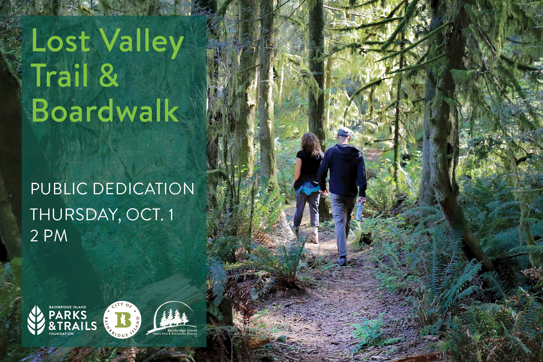
The new Lost Valley Trail opens Oct. 1, fulfilling a 30-year vision and completing the final link in Bainbridge Island's longest cross-island trail route.
The public trail will be celebrated with a ribbon cutting at 2 p.m. Thursday, Oct. 1, hosted by the three project partners: the City of Bainbridge Island, the Bainbridge Island Parks & Trails Foundation, and the Bainbridge Island Metro Park & Recreation District.
"This is a landmark moment for our island trail network," said Mary Meier, Executive Director of the Bainbridge Island Parks & Trails Foundation. "Lost Valley pushes us past the 50-mile mark for public trails islandwide, an incredible mark. A lot of pieces had to fit together over many years, but now we have a new trail route right across the island."
The mostly wooded, mile-long Lost Valley Trail connects the Head of the Bay with Fletcher Bay Road, across 40 acres of public open space. The trail includes 200 feet of boardwalk, protecting the Cooper Creek watershed and ensuring all-season access.
Project funding is by the Bainbridge Island Parks & Trails Foundation. The boardwalk was built by the Park District under an agreement with the City of Bainbridge Island. The Lost Valley Trail is City owned.
The Oct. 1 trail dedication event will be held at the boardwalk at the Head of the Bay (Wyatt Way/Eagle Harbor Drive) trailhead. There is no onsite parking for this event. See map and information below for off-site parking locations, shuttle service to the event site, and trail access.
Please RSVP for the dedication event at www.biparksfoundation.org/lvt-dedication.
THIRTY YEARS IN THE PLANNING
The Lost Valley Trail plan dates to the 1990s, when local trails advocates floated the idea of a "shore to shore" trail route from Winslow to Gazzam Lake Preserve.
In 2004, the City used Open Space Bond funds to purchase three properties and four trail easements (granting rights of public access) at the Head of the Bay, to conserve the land and allow new trails connecting east and west. Informal "social trails" appeared over time but the trail route was never formally improved or adopted.
In 2022, the Bainbridge Island Parks & Trails Foundation approached the City with a proposal to move the Lost Valley project forward, with the Parks & Trails Foundation funding the work. The City Council agreed. At the same time, the Park District entered into an interlocal agreement to build public trails on some City properties, including Lost Valley.
The Parks & Trails Foundation had by this time acquired the final trail easements needed to complete a formal, contiguous trail route from the Head of the Bay to Fletcher Bay Road, with additional trailheads at Carmella Lane (north) and Ridge Lane (south).
Along the way, the Parks & Trails Foundation and Park District developed additional public trails at either end of the Lost Valley, building out the cross-island trail route in both directions. These include the Kojima Trail and Vincent Road to Gazzam Lake Trail to the west.
The boardwalk – the project's final element – was built during summer 2026 by the Park District and the Summer Trails Crew, with funding by the Parks & Trails Foundation. The Bainbridge Community Foundation and Rotary Club of Bainbridge Island provided grant support.
"Lost Valley Trail shows our community's long-term vision and commitment to great recreational trails," said Dan Hamlin, Bainbridge Metro Parks Executive Director. "Our Trails Crew worked through the season to complete the boardwalk, the final piece connecting this route. It's a great example of what we can accomplish when the City, the Foundation and the Park District work together toward a shared goal."
Lost Valley Trail was so named by members of the City Open Space Commission when the property was acquired in 2004. Members at that time noted the property's valley-like terrain, unspoiled nature and sense of remoteness from surrounding roads and neighborhoods.
"The Lost Valley Trail highlights the benefits of connections – to nature, to destinations, and to our neighbors," said John Mauro, City of Bainbridge Island City Manager. "These connections, and the relationships they foster, are emblematic of the culture of Bainbridge Island. Decades of advocacy, collaboration, and commitment to the preservation of public open space came together to make this very special trail possible."
LONGEST CROSS-ISLAND TRAIL
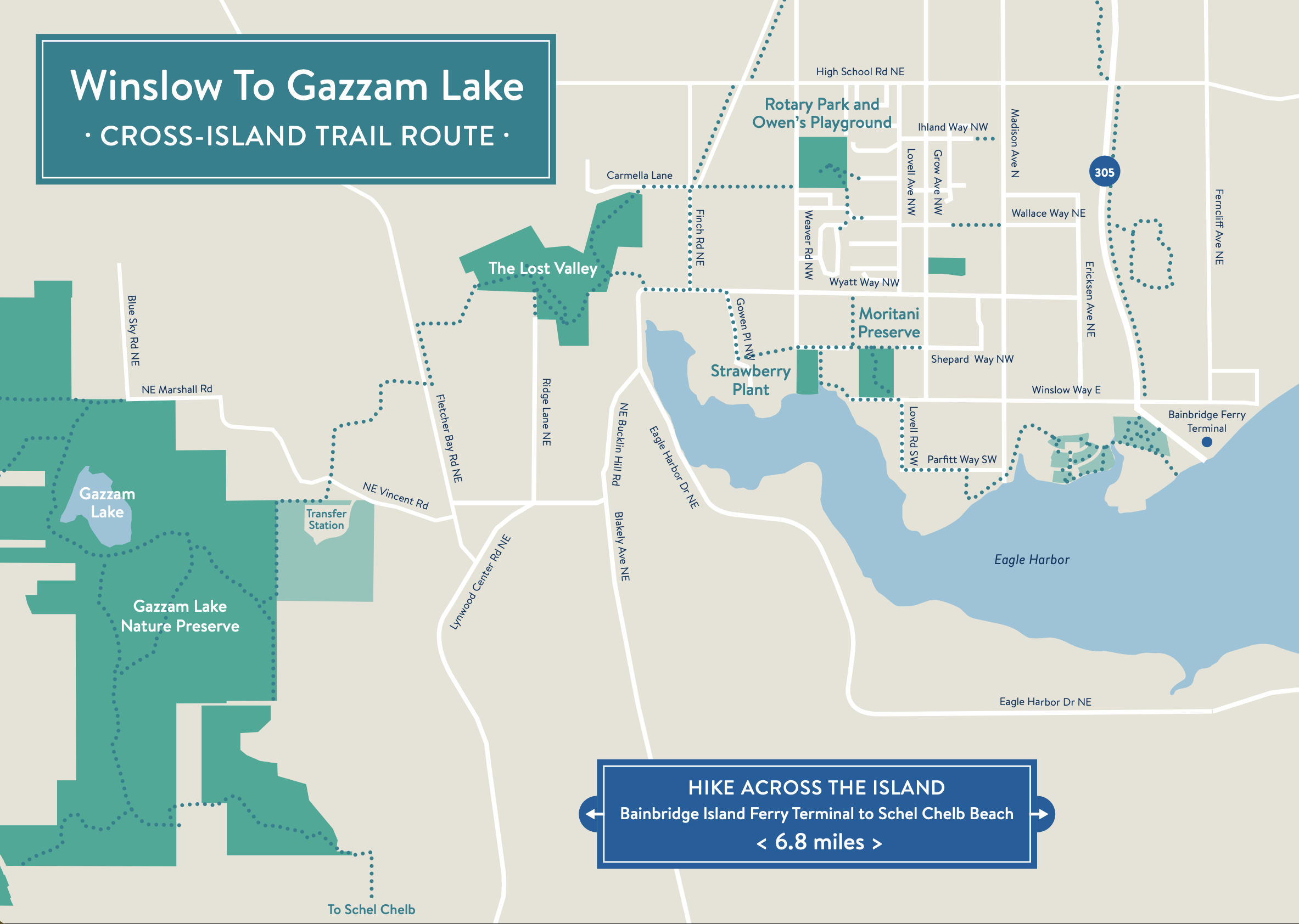
With the opening of Lost Valley Trail, Bainbridge Island now enjoys its longest one-way public trail route – nearly 7 miles – surpassing the cross-island route from Manitou west through Grand Forest to Battle Point Park/Fairy Dell Trail (4.69 miles).
Hikers can now travel approximately 5.1 miles continuously from Rotary Park (Weaver Road) via Lost Valley Trail through Gazzam Lake Nature Preserve to Schel Chelb beach at Lynwood Center, or nearly 6.8 miles from the Bainbridge Island ferry terminal to Schel Chelb. The latter route includes segments of the Charles Schmid Waterfront Trail in Winslow.
REACHING LOST VALLEY TRAIL DEDICATION EVENT
Lost Valley trailheads are at Fletcher Bay Road (east side, north of Vincent Road); Ridge Lane (north end); Carmella Lane (off Finch Road); and from the lane just west of the Head of the Bay, where Wyatt Way meets NE Eagle Harbor Drive. Look for the "Public Trail" signs.
Note: There is no public parking at any of these locations, and the trail must be accessed at all points by foot or bicycle. The trail terrain may not be accessible for users using wheeled mobility devices. For additional accessibility information and for reasonable accommodations, please contact the ADA Coordinator at CityAdmin@bainbridgewa.gov.
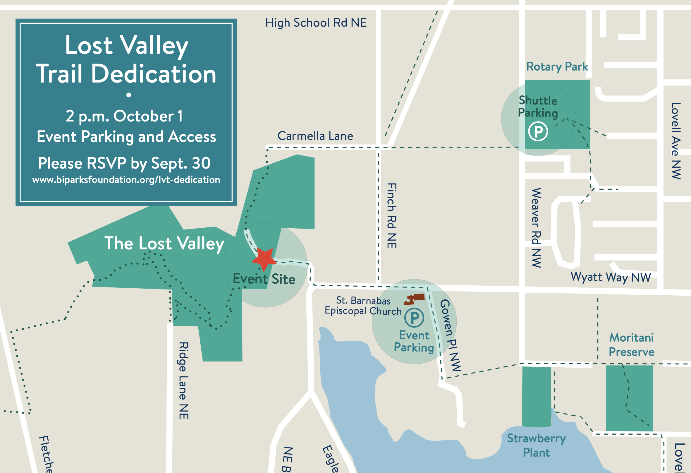
Lost Valley Dedication event parking and shuttle
Lost Valley Trail dedication ceremony begins at 2 p.m. Thursday, Oct. 1, near the trailhead at the Head of the Bay, west of the Wyatt Way/ NE Eagle Harbor Drive turn.
There is no onsite parking at the event, and no parking at any of the four trailheads. Event parking and access options include:
- St. Barnabas Episcopal Church – Park at the lower parking area behind the church (off Gowen Place), then walk down Wyatt Way and turn right at NE Eagle Harbor Drive (the gravel lane north of the Dahlia Stand) to reach the event site. Note: Parking at St. Barnabas is for the day of the event only.
- Rotary Park (Weaver Road) – Park at the lower parking area near the ball fields, where a continuous shuttle will run to the event site, starting at 1:30 p.m. Allow extra time to reach the event ceremonies by shuttle.
You can also hike or bike to the event via any of the three other trailheads: Fletcher Bay Road, Ridge Lane or Carmella Lane. See maps for routes.