Our next two signature trails – the Lost Valley Trail, and Waypoint Woods Gateway Trail – will serve our neighbors across Bainbridge Island. Your gift to the Bainbridge Island Parks & Trails Foundation will make a tremendous impact, and inspire so many others to give.
The Lost Valley Trail
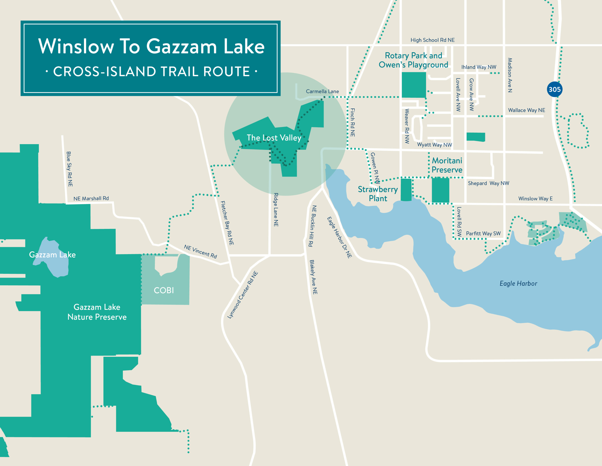
Crossing Bainbridge Island from east to west, linking Winslow to Gazzam Lake
A trail more than 20 years in the planning! Soon to be a jewel of the Bainbridge Island trail system, Lost Valley is the nexus of an east-west, cross-island trail from Winslow all the way to Gazzam Lake and Crystal Springs.
The trail crosses 33 acre of public open space bounded by Wyatt Way/Head of the Bay (east) and Fletcher Bay Road (west), with connections to several neighborhoods along the way. The Lost Valley Trail plan dates to community Open Space Bond of 2001, when island voters overwhelmingly approved purchase of the land and easements to make this trail happen. Additional easements have been acquired by the Parks & Trails Foundation, to create the island’s next great community trail.
Your gifts TODAY will help us begin Lost Valley Trail construction this year. Funding will cover trail construction by the Park District, and City permitting costs for a boardwalk to protect the precious Cooper Creek Watershed and salmon-bearing stream.
Length: 1 mile
Partners: City of Bainbridge Island, Bainbridge Metro Parks
Waypoint Woods Gateway Trail

Welcoming visitors from the ferry to the island’s trail network
Waypoint Woods is a developing gateway to the Bainbridge Island trail system. Visitors leaving the ferry will enjoy landscaped rock plazas, wooded loop trails, Eagle Harbor views and a quiet setting.
First up: a pedestrian stair leading up into the park from the Charles Schmid Waterfront Trail, and trail enhancements throughout the park. Landscaped plazas will follow in the next project phase.
Length: 0.1 mile, connecting to wooded loop trails
Partner: Bainbridge Metro Parks


Two new trails now open!
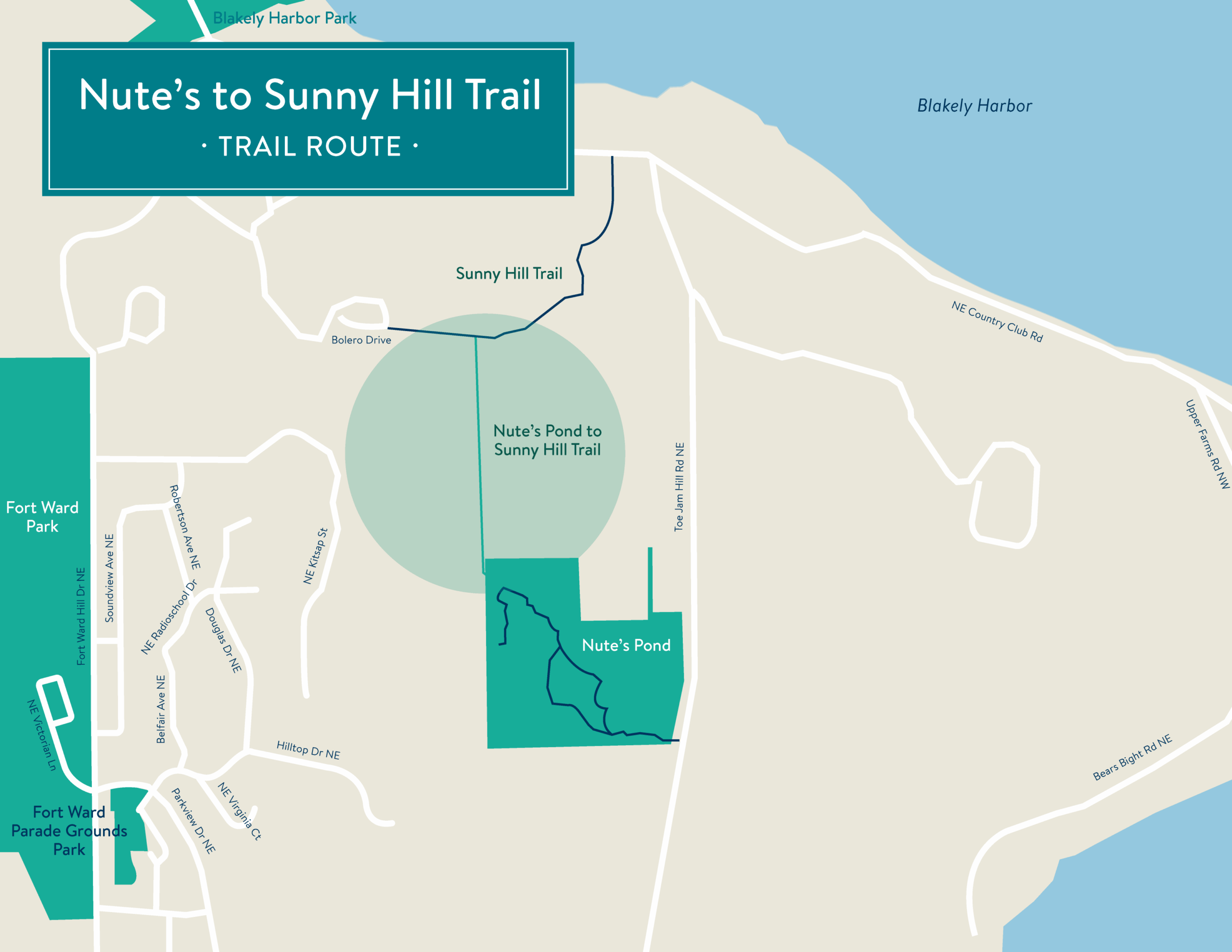
Sunny Hill to Nute’s Pond
A new path to one of the island’s quietest, most picturesque parks
***COMPLETED JUNE 2025***
South Bainbridge Island enjoys a lengthy recreational trail system and some of our most picturesque parks.
This recreational trail will link scenic but isolated Nute’s Pond, via the new Sunny Hill Trail, with parks and neighborhoods – Blakely Harbor, Fort Ward, and to the extensive south-end trail system beyond.
Length: 0.35 mile
Completed: June 2025
Partner: Bainbridge Metro Parks
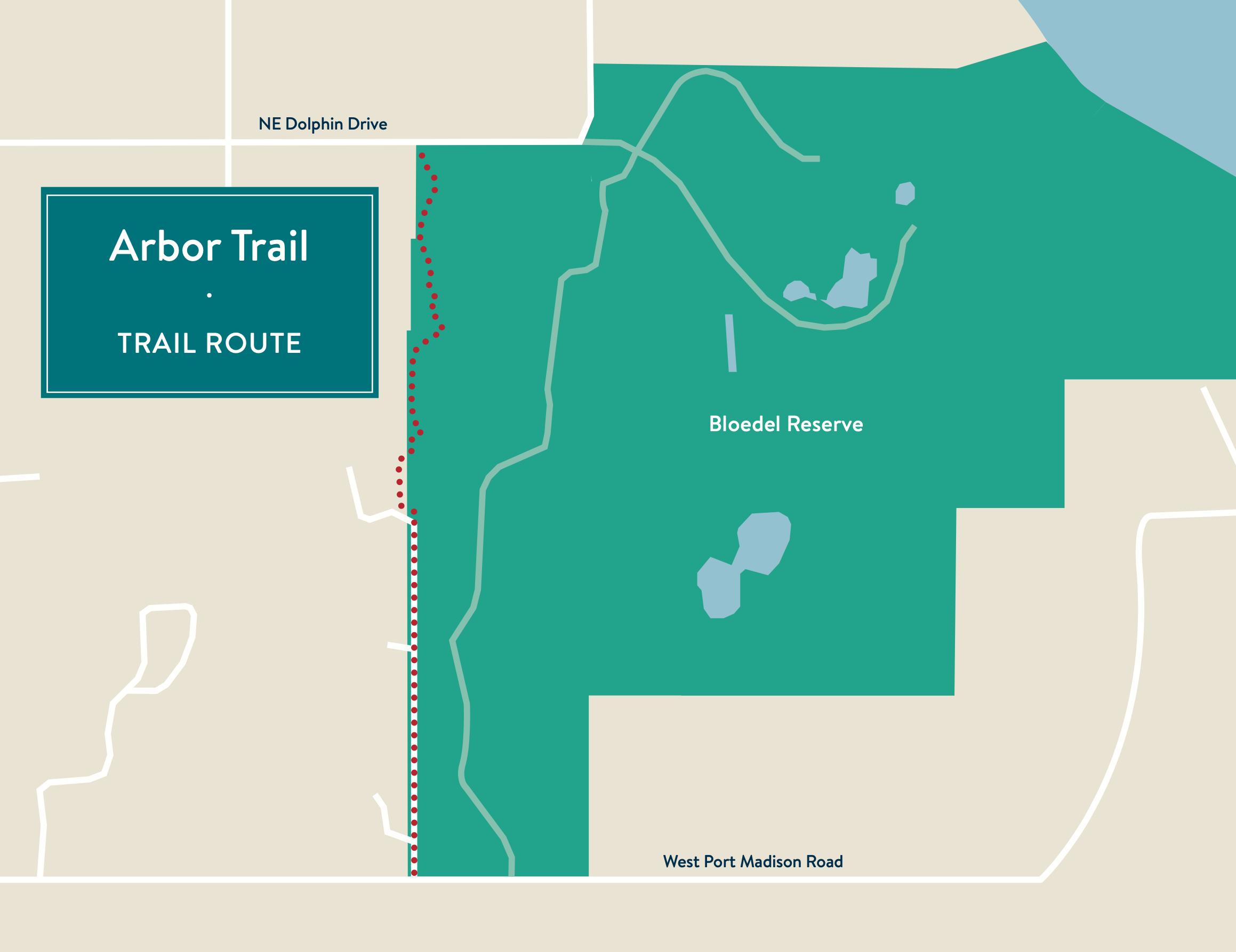
Arbor Trail
Connecting north-end neighborhoods underserved by trails
***COMPLETED NOVEMBER 2024***
NOW OPEN: This trail connects the Agate Pass Loop neighborhood (at Dolphin Drive) with West Port Madison Road
The half-mile winding, wooded trail connects two previously isolated north-end neighborhoods, in an area long underserved by trails. The trail was built in partnership with Bloedel Reserve, which provided an easement along its west boundary.
Length: 0.5 mile
Completed: November 2024
Partners: Bloedel Reserve, Bainbridge Metro Parks
Help build new trails islandwide
Bainbridge Island loves its trails. Year by year, mile by mile, public trails have become one of our most popular features and most valuable community assets.
The Bainbridge Island Parks & Trails Foundation is the community leader in the expansion of our public trails: From our behind-the-scenes work acquiring new trails easements, to coordinating the efforts of local agencies and advocates, the Foundation is a dynamic and effective force in planning, funding, building and maintaining trails island-wide. We are the nexus from which island trails multiply, grow and thrive.
49 miles of trails, and growing – We’re closing in on 50 miles of public trails on Bainbridge Island! We’ve added 10 miles of trails over the past few years – Blakely Hills, Hawley Cove, Gazzam Lake, Old Mill, Sakai Park, the Farmland Trails and more – working in partnership with the Bainbridge Island Metro Park & Trails District, the City of Bainbridge Island, private landowners and generous donors.
Every new trail is an essential part of this growing network, whether a recreational trail serving park goers, a short connector between neighborhoods, or a strategic corridor to schools or commercial centers.
Backed by volunteer commitment – Our 12-member Trails Committee contributes thousands of volunteer hours each year in trails research, appraisals and legal work. We engage private landowners, HOAs, churches, schools and organizations on potential trail routes.
Providing funds to build and maintain – Our work doesn’t stop at trail acquisition. We directly fund trail permitting and construction. We also provide critical funding to Bainbridge Metro Parks for trail-building equipment, and maintenance programs like the Summer Trails Crew.
Planning trails islandwide (and beyond) – Our impact extends regionwide. We lead the Puget Sound to Pacific Collaborative (PS2P), and recently secured a $16M grant for major trail planning from Winslow to the Pacific Ocean. $1.7 million comes to Bainbridge Island to design the Sound to Olympics Trail, from Sakai Park north to the Agate Pass Bridge.
Help build trails with gift today – The Bainbridge Island Parks & Trails Foundation is pleased to share with you our next four trail projects. Find out how you can help build these trails (and many more) with a gift today – contact Mary Meier, mary@biparksfoundation.org or 206.842.4971